5/31/14

My favorite dimsum place in Binondo

 
And it was really love when I first tasted those juicy round dumplings otherwise known as Xiao Long Bao in Binondo. It became sacred ritual for me: You put a dumpling in your soup spoon, Then you bathe it with Chinese vinegar. Pierce a little hole through the soft and delicate wrapper just enough to let out the juices from inside. Close your eyes and slurp the soup that came out. Then you put the dumpling in your mouth and savor everything slowly while you thank God for this wonderful creation.

My friends and I would always make this our lunch stop after rummaging through camera shops in Hidalgo before heading out to Escolta and Manila bay during our photowalks. I learned of this place through Ivan Man Dy's Old Manila Walks and I believe this place gained popularity also through him. Since then people have been going to this restaurant to get a taste of the famed dumplings.

Three years later I've come back to this hole in the wall restaurant to find that nothing much has changed except that it's brighter and cleaner now with a more visible signage outside. Visiting on a Sunday spared me from the waiting time as the place would always be filled with people. There are only 4 table sets inside and one would have to wait in line outside on a regular day.


I did not order Xiao Long Bao but instead asked for Kutchay dumplings with pork. The dumplings are prepared in the dining area so you can see them making the dumpling wrappers and filling with them with kutchay and pork mixture. They also sell frozen dumplings if you want them cooked at home.


Each bite would burst into your mouth releasing irresistible flavors you never quite expected from a simple and unassuming little dumpling. Paired with Chinese vinegar and you could not ask for anything more except maybe for a bowl of fried rice. It sent me back to happier days.

 
 Dong Bei Dumpling is located at Yuchengco Street near Binondo Church.


5/14/14

Ra-Dar


 This was my last solo adventure before my overall health succumbed to infections and allergies which brought back childhood illnesses I thought I never would experience again... oh well.

For the last 5 years or so our family has been going up to Baguio at least twice a year. My dad used to play golf regularly and as such he bought shares in the local golf club to be able to play for free anytime he wanted to. Along with the perks comes free accommodation which we invariably use and avail of every so often or when we feel compelled to especially when the temperature shoots up.

Safe to say that I consider myself a "regular" and that though I am not a local I have an above average knowledge about the comings and goings in Baguio City. And in the last 5 years I've grown accustomed to visiting all the tourist spots so much so that it has become a routine only that unfortunately my greatest observation is that it is getting crowded. The population is dense and the mountains are being overrun by too many houses.

Anyway to go back to the topic at hand. I came across pictures of a place I've never been to, as always, which gave me the urge to check it out. Because as far as I can remember I never had this feeling since the first time I first read through the local tourism office website. This is how I came to know about Mt. Cabuyao.

The directions were pretty straightforward. Take the jeepney going to Green Valley junction which is stationed at Shagem and Otep streets near Burnharm park. Ask to be dropped off at the junction which is marked by an arch right across a Petron Station. Then from there follow the road going to Mount Santo Tomas. Or as I learned by the time I reached the peak, you can use your car all the way up to the peak as the roads are well-paved. The prominent landmarks are the twin radar discs you would see perched atop the mountain.


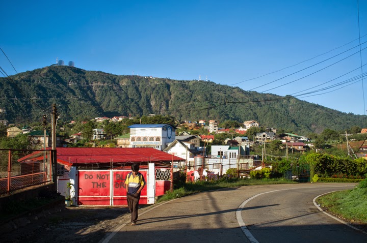
I woke up at around 5AM to start early and took a cab from the country club to Burnharm Park. The weather was cold but manageable. I took the jeepney as instructed and started my long walk at the Green Valley junction. The hike is fairly easy as you just have to follow the road which is only gradually sloping. The road is lined with houses and you will never be far away from civilization. The hike up never gets boring nor tiring as the scenic vistas will slow you down especially seeing the mountains covered in thick mist serving as backdrop to the houses you will encounter along the way.


As I got higher and higher I saw vegetable plantations carved out from the sides of the mountains. Strawberry season has ended and they were already planting what seemed like Chinese cabbage. On occasion I would see hidden paths by the road which led to these plantations.The trails were muddy at that time as it rained the night before.


By the time I reached the top of the mountain I could already see the twin radar discs. More vegetable plantations were there with a small community tending to them. I was lucky in that the peak was not covered in clouds as I was previously informed that the place gets quickly covered by clouds from time to time.


 I walked closer to the satellite disks and found out that these were military installations back then during the American period. The site was off limits to visitors but there is a small path leading to a view deck. I was told the road continues up to the Mt. Sto. Tomas which is the highest peak in Baguio; It would take an extra hour to reach the peak. I attempted to continue on to the peak of Mt. Sto. Tomas but I had to go back already because it was already lunch time so I just looked around and took pictures of people there. I eventually hitched a ride with a local all the way back to the Green Valley junction.


By the way, the locals call the place Ra-Dar owing to the two radar discs. I like it.

5/11/14

Padre Burgos, Quezon


It was another planned trip with my photography friends which we do annually. I was looking for places to go and I found these cluster of islands in Padre Burgos through several blogs I read online. The pictures were really inviting and the place was commutable so the date was set and three of us were going.

Padre Burgos is just a 5-hour bus ride from Metro Manila. We took a JAC Liner bus from Cubao at 3AM in the morning and arrived at the Lucena Grand Terminal by 5AM. We transferred to an ordinary open air bus reminiscent of that bus ride a year ago going to Mauban. The sunrise slowly bringing color to the streets of still sleeping towns and revealing coconut trees covering rolling hills in the distance.


The town itself is small. You could literally walk from anywhere and it was sort of a mistake on our part to immediately hire a tricycle upon arrival when we could've explored the town by ourselves. We bought everything we needed for the overnight stay including water, uncooked meat, squid for grilling and several canned goods. All of it cost us P200.00 each which we thought to be really cheap.

After going to the market, we went straight to where the boats were waiting for us. Boat rental costs P1,800.00 for an island hopping tour to Borawan Island, Dampalitan Island, and Puting Buhangin Cove which is the standard rate as published by the local tourism office. The boat ride was smooth as the water is calm and glassy in the morning. It was a nice treat to see groups of small fishes jumping out of the water in various directions as our boat traces its path along the water.


First stop was Borawan Island. Famous for its limestone karsts akin to those seen in Palawan and having white sand like Boracay. Personally, i felt like the place has its own charm and need not be compared to other famous places previously mentioned. I just dismissed it as a marketing gimmick to attract hordes of tourists simply by giving that name recall. We did not stay long in the island because a lot of people were already there. Word has spread out definitely and while I feel happy for the people benefiting from the influx of visitors I wish the place keeps its charm. As for me I am thinking of going back but maybe during the lean season.


 Next stop was Dampalitan Island. It has the longest beach among the three and the most relaxing during that time. A few meters from the beach, agoho trees form a thick cover perfect for pitching tents to avoid the direct heat of the sun. We stayed here until lunch time. Interesting to note that as the day approaches noon the water recedes and exposes the shallower parts of the sea. A small island consisting of a group of rocks is exposed at high noon.


Our last stop was at Puting Buhangin Cove where the famous Kwebang Lampas is located. We were really excited for this part of the trip as the cove receives the most praises based on the blogs I've read. It was indeed beautiful in its own right. However it was crowded the time we went and was poorly managed by the caretakers. Campers where allowed to pitch tents wherever they want to and garbage was everywhere. It was really crowded that time. It got so noisy at night that we had a very hard time sleeping. It would be better to stay at Dampalitan Island during peak season.


We explored the cove in the morning when everyone was still sleeping and I imagined how it would have been a better experience with just a few people there keeping everything quiet and peaceful. We found our way through the cave and out through the other opening facing the sea. The best part of the trip was when we swam our way staying close to the side of the cliffs  until we reached a secluded small spot away from the crowds. We spent the rest of the morning there just looking out to the open sea.


About Me

My photo
A film P&S and a TLR